Showing posts with label Borders. Show all posts

Thursday, October 07, 2021

Another Set of Mandate of Palestine Maps

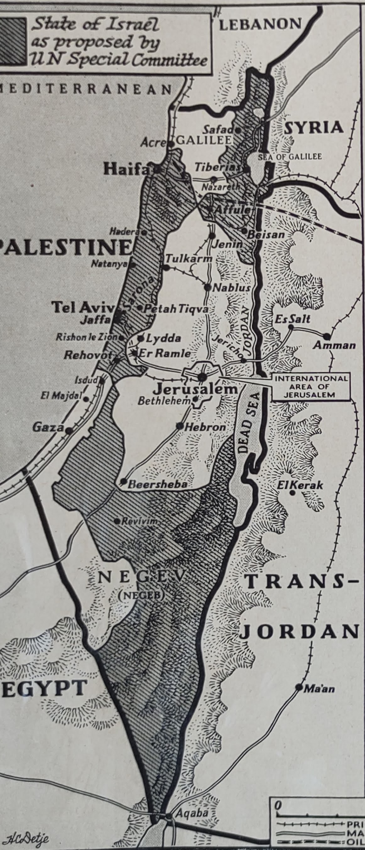
Visiting the offices of the Israel Resource Center, I found another set of Mandate of Palestine maps in this 1948 book:

which even the NYTimes reviewed.

There is a set of maps illustrating the minimizing of the territory of the promised Jewish National Home, ratified by the League of Nations:

And what is unique is that it inludes the summer of 1948 Bernadotte Plan proposal and see here also.

Here is that map in detail:


and here are two others:


Provides more visual perspective on what was being drawn as the borders for the future Jewish and Arab states.

^

Saturday, August 21, 2021

"The Palestinian Side of the Suez Canal"

I found the following in Hansard, the record of Bitish Parliamentary debates. The referred to Milner Mission was to make recommendations for the future relationship between Egypt and England after World War One when Egypt came under British martial law when a temporary Protectorate was declared. Its recommendations were to end that status and the negotiation of a treaty. It was published in February 1921.

The debate was held on March 14, 1922.

The following extract is from the words of John Mills. In 1923, he served as Parliamentary Private Secretary to the pro-Zionist Josiah Wedgwood.

Mills make the point that Egypt really never was any part of the British Empire and in doing so, makes reference to the concept that Palestine should extend well into Sinai, right up to the Suez Canal:
This point is specifically alluded to on page 6 of the Milner Report. I am quoting from the Report of the Special Mission, and it says: It appears to be frequently assumed in current talk and writing in this country that Egypt is part of the British Empire. That is not, and never has been, the case. That is most explicit, and to gentlemen of military experience who talk to us about the tactical value of this or that part of a country, I would suggest that on the Palestinian side of the Suez Canal you have a population who at the moment are welcoming British occupation, and, under the pledge given to the Zionists, it makes it a desirable circumstance for the transfer of the garrison; that in itself is an alternative place where troops can be kept if the Suez Canal is deemed to be such a dangerous part of our communication. Personally I think that the international pact which guaranteed the international character of the Suez Canal makes a very large number of these assertions valueless even if they ever contained some, amount of value. Having regard to the changed circumstances in the East, having regard to the changed circumstances on the Palestinian side of the Canal, we are justified in asking this Government and its military advisers to consider the alternative garrison for the troops, if they are necessary, in order that we may in fact as well as in word carry out this generation-long pledge to the Egyptian people.

Later in the debate Colonel Wedgewood notes:

Indeed, I think it is worth considering whether it would not be possible even to have the troops on the Eastern bank of the Canal instead of on the Western bank, provided that the Palestine-Egyptian frontier were shifted from the Akaba line up to the Suez Canal. That shift in the frontier would put us on the Suez Canal, in a position where we could adequately protect that Canal, with a base in the mandated country of Palestine, where we should be permanently on the spot to protect the Canal and look after our interests.

He is referring to the October 1, 1906, Separating Administrative Line between the Ottoman province of the Hejaz, the governorate of Jerusalem and the Sinai Peninsula which was agreed upon, following nine months of military action and diplomatic activity which nearly brought the British and the Ottoman empires to the verge of war. See here


It began in January that year when British forces from Egypt 
to build up a small post for the Egyptian border police at Umm Rashrash (now Eilat) in Naqb al-Aqaba. Their presumption was that "Naqb el-Akaba... is well within the frontier line settled upon between Turkey and Egypt" after the Wedj incident. 


Taba was then occupied by Turkish troops.

Oddly enough, one of the elements involved in the background to all this dispute was an

"1892 incident [that] was caused, according to Cromer, by the suspicions of the Sultan with regard to planned Jewish settlement on the shores of Aqaba: ‘...The result was that the Firman laid down the Egyptian frontier as drawn from Suez to El-Arish. The peninsula of Sinai, which had been administered by the Khedives of Egypt for the last forty years, would thus have reverted to Turkey... ’

Tuesday, December 11, 2012

Stating State Thoughts

From behind-the-scenes thinking:-

The recent vote in the United Nations General Assembly to give non-member observer state status to the Palestinian Authority contains no new legal or diplomatic information.  Even Palestinian self-determination cannot be denied.

There is already recognition of the Palestinians as a state but, on the other hand, it contradicts the tropes about Israeli oppression, occupation and apartheid. They have been functioning as a state, conducting foreign relations, making deals and acting entirely independently of Israel. This is not a Bantustan overseen by Israel. In the wake of the UN vote, Palestine opened a defense ministry and began discussing issuing passports. No people
under occupation have all these trappings of self-determination and statehood.

What is the UN bid about? Certainly not statehood. Even Israel supports that.


The issue is what are the borders of this 'state'?


The PA will not be satisfied with a declaration of statehood and self-determination but they demand that their state include what in the Oslo Process was dubbed Area C – regions that are overwhelmingly Jewish.

Roughly four percent of Palestinians live in Area C, while 100% of Jews in the West Bank live there.

So, can we forget about occupation and apartheid and define the dispute as one that is territorial?  A fight between equal neighbors, in the legal and diplomatic sense?


After all, such controversies are commonplace.  There's India, China, Russia, Japan and other nations which maintain controversies over frontiers.

But is it simply a border question?

Or is it really a dispute/conflict over whether Jews should have borders, at all or partial?   A dispute over Israel's right to exist at all and that's why every territorial concession is met with more violence in word and deed.

Hamas (a la Mashal) insists on a total negative :-

 “Palestine from the river to the sea, from the north to the south, is our land and we will never give up one inch or any part of it.”

Fatah fudges, never really comitting itself and always insisting on right of return (including into pre-67 Israel), Jerusalem, Jewish ethnic cleasing in 'Palestine'.

There are, of course, two additional problems stemming from the text of the Oslo Accords:

a) they actually want "the Civil Administration in the West Bank will be dissolved, and the Israeli military government shall be withdrawn."

and

b) the area of that state should be in accordance with: - "The two sides view the West Bank and the Gaza Strip as a single territorial unit, the integrity and status of which will be preserved during the interim period.

2. The two sides agree that West Bank and Gaza Strip territory, except for issues that will be negotiated in the permanent status negotiations, will come under the jurisdiction of the Palestinian Council.

One need not be a an internation law professor to realize that it is obvious that that language permits Israel to demand a part of J&S to be retained by Israel but the Pals. will not yield on that (Arafat Camp David II).

Is there a reasoned and rational solution that will assure Israel's security?

Retention, it is.

^

Sunday, December 11, 2011

"Palestine"? What Borders? Where?

Apropos the latest "outrage" of Arabs of the former Mandate for Palestine, let's recall that in The Treaty of Peace Between The Allied and Associated Powers and Turkey signed at SÈVRES, August 10, 1920, Section VII, Syria, Mesopotamia, Palestine, Article 94, we read:

The High Contracting Parties agree that Syria and Mesopotamia shall, in accordance with the fourth paragraph of Article 22.

Part I (Covenant of the League of Nations), be provisionally recognised as independent States subject to the rendering of administrative advice and assistance by a Mandatory until such time as they are able to stand alone.

A Commission shall be constituted within fifteen days from the coming into force of the present Treaty to trace on the spot the frontier line described in Article 27, II (2) and (3). This Commission will be composed of three members nominated by France, Great Britain and Italy respectively, and one member nominated by Turkey; it will be assisted by a representative of Syria for the Syrian frontier, and by a representative of Mesopotamia for the Mesopotamian frontier.

The determination of the other frontiers of the said States, and the selection of the Mandatories, will be made by the Principal Allied Powers.

ARTICLE 95.

The High Contracting Parties agree to entrust, by application of the provisions of Article 22, the administration of Palestine, within such boundaries as may be determined by the Principal Allied Powers, to a Mandatory to be selected by the said Powers. The Mandatory will be responsible for putting into effect the declaration originally made on November 2, 1917, by the British Government, and adopted by the other Allied Powers, in favour of the establishment in Palestine of a national home for the Jewish people, it being clearly understood that nothing shall be done which may prejudice the civil and religious rights of existing non-Jewish communities in Palestine, or the rights and political status enjoyed by Jews in any other country.

The Mandatory undertakes to appoint as soon as possible a special Commission to study and regulate all questions and claims relating to the different religious communities. In the composition of this Commission the religious interests concerned will be taken into account. The Chairman of the Commission will be appointed by the Council of the League of Nations.

Although there is some dispute regarding the legality of the treaty - for

"while the treaty was under discussion, the Turkish national movement under Mustafa Kemal Pasha split with the monarchy based in Constantinople and set up a Turkish Grand National Assembly in Ankara in April 1920.  On October 18, the government of Damat Ferid Pasha was replaced by a provisional ministry under Ahmed Tevfik Pasha as Grand Vizier, who announced an intention to convoke the Senate with the purpose of ratification of the Treaty, provided that national unity were achieved. This required seeking for cooperation with Mustafa Kemal. The latter expressed disdain to the Treaty and started a military assault. As a result, the Turkish Government issued a note to the Entente that the ratification of the Treaty was impossible at that time.  Eventually, Mustafa Kemal succeeded in his fight for Turkish independence and forced the former wartime Allies to return to the negotiating table.  Arabs were unwilling to accept the French rule in Syria, the Turks around Mosul were attacking the British, the Arabs were in arms against the British rule in Baghdad. There was also disorder in Egypt...the former Allies of World War I [returned] to the negotiating table with the Turks and in 1923 negotiate the Treaty of Lausanne, which replaced the Treaty of Sèvres...

Nevertheless, the point I am making is the principle:

"Palestine" had no boundary definition.  There was no physical concept or identity.  No delineation. It was all in the mind. The Turks and the Arabs didn't conceive of a country but of a general territory.  The Allies in the League of Nations drew the maps and before, in the 1919 Versailles Peace Conference, the instruction was "from Dan to Beer-Sheva".

It, in this sense, didn't really exist.

^

Wednesday, November 09, 2011

Where Is/Are Israel's Border/s?

I have been informed that the next Memory and Identity Working Group, of the University of California at Berkeley meeting will be on the subject: The History of the Map of Israel presented by Rachel Havrelock, University of Illinois, Chicago to take place on Monday November 14, 2011, 4:00 pm, 254 Barrows Hall.


An explanation:

What are the legitimate borders of Israel? Who should determine where they fall? When should the borders become permanent? These are just a few of the controversial questions that surround Israel's border disputes.

In this talk, Professor Rachel Havrelock explains how the existing borders came into being and the reasons why they are disputed. Religious traditions, the European creation of the modern Middle East, and the wars of the 20th century all contribute to the current as well as the proposed maps of the region. Accompanied by a power point presentation of historical maps, Havrelock will tell the stories behind the borders and show how, from biblical times to the present, many interpretations of the map of Israel have coexisted.

This event is co-sponsored by the Near Eastern Studies Department, the Jewish Studies Program, and the Townsend Center for the Humanities and is part of the Memory and Identity Working Group lecture series. Memory and Identity Working Group meetings are designed to encourage dialogue across the department's diverse traditions.

Now, if you are thinking that Israel will be staunchly defended, think again:

Rachel Havrelock is a scholar of the Hebrew Bible and its interpretation...Rachel began her graduate work at Tel Aviv and Bir Zeit Universities, continuing and completing it in the Joint Doctoral Program in Jewish Studies at the University of California, Berkeley and the Graduate Theological Union.
...Rachel is...the author of "The Two Maps of Israel's Land," Journal of Biblical Literature 126:4 (2007): 649-667; "My Home is Over Jordan: River as Border in Israeli and Palestinian National Mythology," National Identities 9:2 (2007): 105-126;...

Rachel is completing River Jordan: The Mythic History of a Dividing Line, a manuscript that considers the Jordan River as a border in the Bible, in Rabbinic and Patristic exegesis and in Jewish and Palestinian nationalisms.

She has written and directed hip-hop plays, From Tel Aviv to Ramallah and Soundtrack City...

In that "play", she promotes the idea about Israel's border that

a dividing line. The dividing line in question is the Green Line, a militarized boundary that separates Israel from the occupied Palestinian West Bank.

Oh, oh.

She is also known as a 'mythbuster'.

Oh, oh, oh.

^

Wednesday, November 02, 2011

And the Borders of "Palestine" Are...

Well, according to Mahmoud al-Zahar, who supports Palestinian Authority (PA) Mahmoud Abbas's UN membership bid and establishment of a Palestinian State within the 1967 borders, they are "well known".

Do you know what those borders are?

No?  Here:-

"But, the occupying regime should not be recognized and even a span of Palestine's soil should not be ignored," Zahar noted.

"If efforts are directed towards establishment of a Palestinian state based on 1967 borders, we should unify our efforts. Of course this is not our borders, our borders are well known and cover the entire Palestine and even more than Palestine," Zahar stated.

In in other words, no borders for Jews.

And more land for Arabs.  I presume he means...Jordan.

Abdallah, "Jordan is Palestine" indicates Hamas?


(k/t=IMRA)

^

Friday, August 14, 2009

Let's Let Peter Hitchens Speak

From here:

...I would add that I am always amused by the enthusiasm which Israel's enemies now show for the pre-1967 border of Israel. Their alleged enthusiasm for it now is a fake. Their real objective, as enshrined for decades in the policy documents and propaganda of the Arab world, (though in some cases tardily, reluctantly and insincerely shelved for Western consumption) is the end of the Jewish state altogether. Every Arab political figure in the area has on his wall a map of the region, a map from which Israel has entirely vanished. Hizbollah works for the extirpation of Israel, from just beyond its northern border. Hamas (a movement whose treatment of fellow Arabs who oppose it is extremely repressive and violent) continues to make no secret of this aim. Racialist filth and Judophobic slurry are taught to children in the Arab states and broadcast on Arab TV stations. And until they abandon this aim, and this muck, there can be no compromise. How can you compromise with people who teach tiny children to hate you, and whose aim is your utter destruction? Every concession would merely be a further step towards death, not a step towards peace.

I am old enough to recall that these enthusiasts were not so enthusiastic about the pre-1967 border before 1967, when it was the border of Israel. No Arab state accepted it as legitimate, let alone lawful. So why are they so keen on it now? I guarantee that if the 1967 border were to be restored tomorrow, the Arab campaign against Israel (backed elsewhere by our strange Israel-haters, who can only find one country on the map of the world to disapprove of) would continue unabated. At that stage, before 1967, the official policy of the Arab world was to 'drive the Jews into the sea'. The 1967 border itself, a militarily indefensible and impractical frontier, was the cease-fire line at the end of the 1948 War, not an internationally agreed frontier between peaceful sovereign states. For most of its existence it was repeatedly violated.

The 1948 war was itself caused by the Arab world's rejection of the 1947 partition plan, which allocated Israel a much smaller territory even than the land enclosed in the supposedly sacred 1967 border. That rejection itself followed the similar rejection of the partition proposed by the 1937 Peel Commission, which was even less generous to the Jews than the UN would be ten years later. All this in fact goes back to Sir Herbert Samuel's choice (into which he was manoeuvred by the interesting Ronald Storrs), against the opposition of the Palestine Arabs, of the appalling Haj Amin al Husseini as Grand Mufti of Jerusalem in 1921, which set the Arabs of the region on the path of war rather than the path of civilised compromise. Storrs was one of many in the British colonial service who sought to backtrack on the promise made in the Balfour Declaration, of a 'national home' for the Jews - and it was their tireless lobbying and dirty tricks which in my view created the mess we're now in. I am of course concerned by any injustice done to the Arab people of the Middle East, and readily agree that Israel has often behaved very badly towards many Arabs. I've written a lengthy article on their flawed and foolish treatment of the Bedouin in Israel, and of the Israeli Arab minority. But much injustice against Arabs is done by Arab states, Arab rulers and Arab movements, and I would be more convinced of the genuineness of the partisan passion of persons such as Mr Lawson and his band of inflamed supporters (who rushed in to back him without bothering to read what he and I had written, which small effort would have shown that he was basing at least part of his attack on a misquotation) if they ever concerned themselves with Arab injustice towards Arabs.

For instance, they might condemn explicitly the persecution of Arab Christians by Arab Muslims in Bethlehem, or the Syrian state's mass murder (by artillery) of Muslim Brotherhood supporters in the city of Hama, or the discrimination against Palestinian refugees throughout the Arab world. But they never do. It is always Israel, Israel, Israel. My suspicion, until they show otherwise, is that they are more interested in attacking Israel then in defending unjustly-treated Arabs.


See, too, here and the comment of James Lawson at 04:26 PM.

Thursday, July 23, 2009

Borders - 1919


Background:

1919. With the war over, and as preparations for the Paris peace talks began at Versailles in early 1919, border requirements were again refined by each side, as follows.

Zionist position

The Zionists began to formulate their desired boundaries for the "national home," to be determined by three criteria - historic, strategic, and economic considerations (Zionist publications cited in Ra'anan 1955, 86).

Historic concerns coincided roughly with British allusions to the biblical "Dan to Beersheba." These were considered to be minimum requirements, which had to be supplemented with territory that would allow military and economic security. Military security required desert areas to the south and east as well as the Beka'a Valley, a gateway in the north between the Lebanon Mountains and Mount Hermon.

Economic security was defined by water resources. The entire Zionist programme of immigration and settlement required water for large-scale irrigation and, in a land with no fossil fuels, for hydropower. The plans were "completely dependent" on the acquisition of "the headwaters of the Jordan, the Litani River, the snows of Hermon, the Yarmuk and its tributaries, and the Jabbok" (Ra'anan 1955, 87).

In a flurry of communication between world Zionist leaders, the aspects of historic, strategic, and economic security became increasingly linked with the Jordan headwaters. These leaders of diverse backgrounds (including Chaim Weizmann, a British chemist whose wartime contribution of the gunpowder-refining process to the Allies granted him a certain status among British decision makers; Aaron Aaronsohn, a Palestine-born agriculturalist who had undertaken intelligence operations on Turkish troop movements for the British; and Louis Brandeis, a US Supreme Court Justice) each became demographer, cartographer, hydrologist, and strategist, in preparation for the Peace Conference.

The guiding force in refining the thinking on the necessary boundaries was Aaron Aaronsohn. He was in charge of an agricultural experimental station at Atlit on the Mediterranean coast, where his research focused on weather-resistant crops and dry-farming techniques. Convinced that the modern agricultural practices that would fuel Jewish immigration were incompatible with "the slothful, brutish Ottoman regime" (Sachar 1979,103), he concluded that Zionist settlement objectives required alliance with the incoming Allied Forces. Aaronsohn initiated contact with the British to establish a Jewish spy network in Palestine, which would report on Turkish positions and troop movements. Perhaps because of his training both in agriculture and in security matters, he became the first to delineate boundary requirements specifically with regard to future water needs. Aaronsohn's "The Boundaries of Palestine" (27 January 1919, unpublished, Zionist Archives), drafted in less than a day, argued that

In Palestine, like in any other country of arid and semi-arid character, animal and plant life and, therefore, the whole economic life directly depends on the available water supply. It is, therefore, of vital importance not only to secure all water resources already feeding the country, but also to insure the possession of whatever can conserve and increase these water - and eventually power - resources. The main water resources of Palestine come from the North, from the two mighty mountain-masses - the Lebanon range, and the Hermon ...

The boundary of Palestine in the North and in the North East is thus dictated by the extension of the Hermon range and its water basins. The only scientific and economic correct lines of delineation are the water-sheds.

Aaronsohn then described the proposed boundaries in detail, as delineated by the local watersheds. He acknowledged that, with the exception of the Litani, the Lebanon range sends no important water source towards Palestine and "cannot, therefore, be claimed to be a 'Spring of Life' to the country." It is the Hermon, he argued, that is "the real 'Father of Waters' and cannot be severed from it without striking at the very root of its economic life."

Returning to the Litani, however, Aaronsohn suggested that

[it] is of vital importance to northern Palestine both as a supply of water and of power. Unfortunately its springs lie in the Lebanon. Some kind of international agreement is essential in order that the Litani may be fully utilised for the development of North Palestine and the Lebanon.


Aaronsohn's rationale and boundary proposals were adopted by the official Zionist delegation to the Peace Conference, led by Chaim Weizmann. The "Boundaries" section of the "Statement of the Zionist Organization Regarding Palestine," which paraphrased Aaronson's proposals, read, in part (see appendix II for the complete text):

The economic life of Palestine, like that of every other semi-arid country depends on the available water supply. It is therefore, of vital importance not only to secure all water resources already feeding the country, but also to be able to conserve and control them at their sources.

The Hermon is Palestine's real "Father of Waters" and cannot be severed from it without striking at the very root of its economic life ... Some international arrangement must be made whereby the riparian rights of the people dwelling south of the Litani River may be fully protected. Properly cared for these head waters can be made to serve in the development of the Lebanon as well as of Palestine. (Proposals dated 3 February 1919, Weizmann Letters 1968, appendix II)

Interestingly, Aaronsohn thought his ideas had been badly mangled in the Proposals, perhaps because he was not included in the final drafting. In an angry letter to Weizmann, he complained that the draft was "a disgrace and a calamity" (emphasis Aaronsohn's), and expressed shock that, for one of the delegates, "a 'watershed' is the same as a 'thalweg.' Incredible, but true" (unpublished fetter, 16 February 1919, Weizmann Archives).

In June 1919 Aaronsohn died in a plane crash (at the time deemed by the Zionists "mysterious") on his way to the Peace Conference and the Zionist proposals were submitted without revision. Nevertheless, the importance of the region's water resources remained embedded in the thinking of the Zionist establishment. "So far as the northern boundary is concerned," wrote Chaim Weizmann later that year, "the guiding consideration with us has been economic, and 'economic' in this connection means 'water supply"' (18 September 1919, Weizmann Letters, 1968).

Sunday, May 04, 2008

Eli Hertz on Boundaries

"Israeli and Palestinian negotiators should decide once and for all where to draw the line between Israeli and Palestinian territory, ending the argument over Jewish housing expansion on disputed ground."

U.S. Secretary of State, Condoleezza Rice. Thursday, May 1, 2008


And Erekat adds:

Seeking a more active American role in talks with Israel, the Palestinians say they hope that Secretary of State Condoleezza Rice will “take a stand” on the borders of a future Palestinian state and define them as corresponding with the 1967 lines, a senior Palestinian official said Saturday.

One-nine-six-seven — we need to hear these four digits,” Saeb Erekat, the chief Palestinian negotiator, said in a telephone interview.


But the border conflict did not begin with 1-9-6-7. In fact the 1-9-4-7 borders, much smaller then the 1-9-6-7 boundaries were rejected by the Arabs at the time.


Eli Hertz writes:-

The Line Has Already Been Drawn and is Backed by International Law!

On September 16, 1922, the final [not yet, Eli] geographical area of Jewish Palestine was drawn by the League of Nations for the Jewish National Home.

From the League of Nations Report:

PALESTINE [Eretz-Israel]
INTRODUCTORY.
POSITION, ETC.

"Palestine lies on the western edge of the continent of Asia between Latitude 30° N. and 33° N., Longitude 34° 30' E. and 35° 30' E.

On the North it is bounded by the French Mandated Territories of Syria and Lebanon, on the East by Syria and Trans-Jordan, on the South-west by the Egyptian province of Sinai, on the South-east by the Gulf of Aqaba and on the West by the Mediterranean. The frontier with Syria was laid down by the Anglo-French Convention of the 23rd December, 1920, and its delimitation was ratified in 1923. Briefly stated, the boundaries are as follows: -

North. - From Ras en Naqura on the Mediterranean eastwards to a point west of Qadas, thence in a northerly direction to Metulla, thence east to a point west of Banias.

East. - From Banias in a southerly direction east of Lake Hula to Jisr Banat Ya'pub, thence along a line east of the Jordan and the Lake of Tiberias and on to El Hamme station on the Samakh-Deraa railway line, thence along the centre of the river Yarmuq to its confluence with the Jordan, thence along the centres of the Jordan, the Dead Sea and the Wadi Araba to a point on the Gulf of Aqaba two miles west of the town of Aqaba, thence along the shore of the Gulf of Aqaba to Ras Jaba.

South. - From Ras Jaba in a generally north-westerly direction to the junction of the Neki-Aqaba and Gaza-Aqaba Roads, thence to a point west-north-west of Ain Maghara and thence to a point on the Mediterranean coast north-west of Rafa.

West. - The Mediterranean Sea."


Of course, I would insist that the original demarcartion is still relevant, the one that looks like this:


Oh, you think that map above is a Zionist propaganda trick? Well, here's a Pal. version: